PHOTO
Severe weather warning: Friday, October 18 - 10:52am
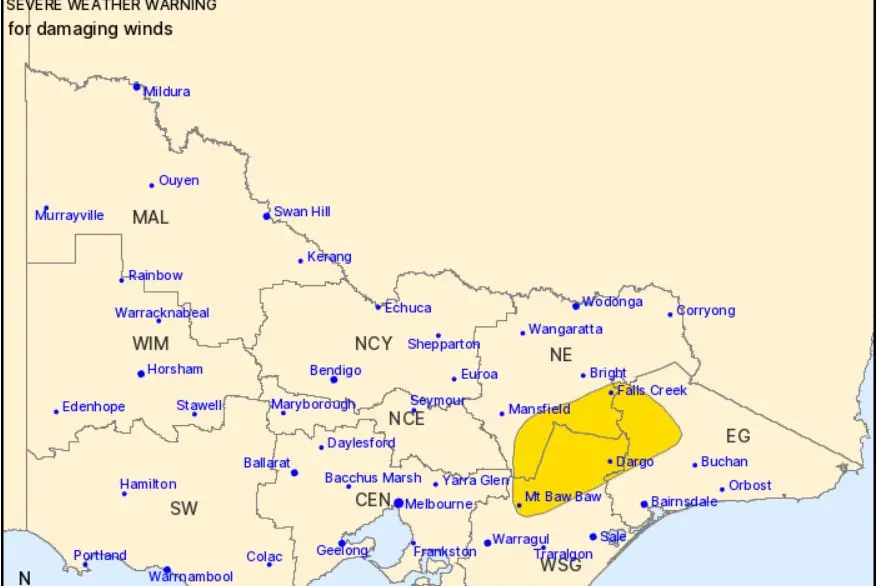
A DEEP low pressure system will cross southern Victoria and Bass Strait today.
Vigorous northerly flow ahead of the low will shift westerly during the afternoon, with gusty conditions expected.
Damaging winds averaging 60 to 70 km/h with peak gusts of around 100 km/h are expected about the northeast ranges.
The risk of damaging winds is forecast to ease during the early Friday afternoon.
Separate severe thunderstorm warnings are likely during Friday affecting parts of Victoria, refer to http://www.bom.gov.au/vic/warnings/ for more information.
Locations which may be affected include Dargo, Mt Baw Baw, Falls Creek, Mt Hotham, Mt Buller and Omeo.
Significant wind observations to 10:40 AM AEDT include:
103 km/h gust recorded at Mount Hotham AWS at around 10:40 AM AEDT
90 km/h gust recorded at Mount Buller Airport at around 9:54 AM AEDT
The State Emergency Service advises that people should:
* If driving conditions are dangerous, safely pull over away from trees, drains, low-lying areas and floodwater. Avoid travel if possible.
* Stay safe by avoiding dangerous hazards, such as floodwater, mud, debris, damaged roads and fallen trees.
* Be aware - heat, fire or recent storms may make trees unstable and more likely to fall when it's windy or wet.
* Check that loose items, such as outdoor settings, umbrellas and trampolines are safely secured. Move vehicles under cover or away from trees.
* Stay indoors and away from windows.
* If outdoors, move to a safe place indoors. Stay away from trees, drains, gutters, creeks and waterways.
* Stay away from fallen powerlines - always assume they are live.
* Be aware that in fire affected areas, rainfall run-off into waterways may contain debris such as ash, soil, trees and rocks. Heavy rainfall may also increase the potential for landslides and debris across roads.
* Stay informed: Monitor weather warnings, forecasts and river levels at the Bureau of Meteorology website, and warnings through VicEmergency website/app/hotline.
The next Severe Weather Warning will be issued by 5pm AEDT Friday at http://www.bom.gov.au/vic/warnings/